A. Ferrero (1,2), V. Monteserín (2), J.M. Baltuille (2), P. Gumiel (3) y F. Bellido (4)
1: Instituto Geológico y Minero de España 2.- Oficina de Proyectos de Santiago de Compostela, Área de Rocas y Minerales Industriales 3.- Área de Metalogenia y Geoquímica 4.- Área de Estudios Geológicos
The solid rock of O Porriño is located in the SO part of the province of Pontevedra (Galicia) and with a subcircular morphology it extends some 25 km in the N-S direction with width varying from 15 km in the north to 10 km to the south.
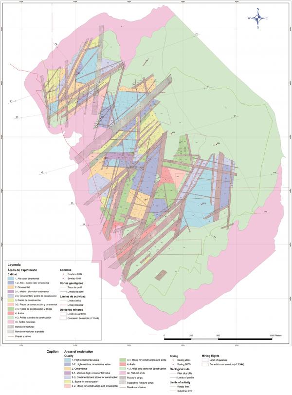
The variety Rosa Porriño is extracted in the concession of the exploitation Benedicta (nº 1544) located in the northwest part of the rock occupying a surface of 6.8 square km. The exploitations (39 quarries) are concentrated in an area of about 2 square km in the eastern part of the solid mass.
Of the Rosa Porriño layer, granite is extracted in blocks, stone for construction, and arid mainly for cement. The ornamental rock is destined both for the local market as well as exports, being commercialised in a large number of countries (emblematic works realised with this granite are, among others, the Tokyo City Hall and the headquarters of the European Parliament in Brussels).
The company, Pocasa-Porriñesa de Canteiras S.A., is the owner of the concession for exploitation of "Benedicta" located in the municipality of O Porriño and in which several operators are grouped together. With the aim of realising a project for the renovation of the concession of the exploitation, the above named company ordered a geological-mineral based study for calculating the reserves and planning the use of mining resources in the current area of exploitation, as well as a general cartography of the entire concession.
The extent of the cartography of industrial qualities
There is no doubt that once identified the deposit of commercial interest as is the case of some natural stones, it is convenient to design its exploitation in such a way that the output in economic terms be the highest possible within the range of sustainability, both from the socio-economical as well as environmental perspective.
To deal with the task of designing and planning the exploitation of a deposit with the aim of optimising and to be profitable in the use of the mineral resource, it is necessary to have geological-mineral information on a scale adequate to the dimensions of the deposit, its useful substance, and its potential destination. This information ought to be captured in a paper or digital support in a way that it can be used with different criteria, and allows not only the calculation of reserves in a useful way, but also the election of more adequate areas to establish both the temporary as well as fixed installations, as also for the design of the pathways and the gaps in exploitations, the direction of the advance, etc.
The working method to be used and the level of detail one aims at arriving, has much to do with the previously available information and the observation conditions. In each specific case, one has to make the best adaptation possible of the general methodology of investigation of granites made to date by IGME during the development of several works, realised with the aim of understanding the potential of natural stones in Spain.
The previous works of IGME were bereft of necessary details for directly applying the criteria of making cubic reserves. Neither did the geological-mineral information collected in the work of cubication, provide the necessary details for the estimation of reserves adequate to the current interests of the company. That is why IGME decided to do a lithological and detailed structural cartography, and a cartography of industrial qualities, which is what was considered adequate for the objectives of the project, working for it at a scale of 1:1000.
For the entire concession a geological cartography at a scale of 1:10000 was done. Given the existence of practically continuous reaching till the surface in the area of current exploitation, due to the intense actual exploitation, a detailed observation was done of the fronts and working platforms. The results are represented on a geological map, in which the existing lithologies stand out on a scale of 1:3500, the fractures, the veins, some significant changes in colour in the common fronts of granite, as well as some areas with greater presence and size of enclaves. Special attention was paid in the establishment of the limit that separates the front Rosa Porriño porphyric equigranular to the inequigranular, from the porphyric front Rosa Porriño porphyric, which the quarriers assimilate, to the commercial variety Rosa Dante. Also the areas of sand-alteration of granite were marked out, as well as the areas covered by the deposits of Quaternary.
Cartography of industrial qualities
The interesting data of all in the detailed studies, and which, in great measure, are acquired simultaneously, can be grouped in two parts:
- Data in relation to the quality of granite for natural stone and arids.
- Data in relation with the existence of extractable volume with economic benefit.
The geological-mining cartography constituted the first phase of obtaining the cartography of industrial qualities on a 1:1000 working scale and presented on a scale of 1:3500. For the cartography of industrial qualities no technological testing was done because taking into account the extension to be cartographed (a little more than 2 square km) and the previous knowledge available on technological qualities of granite in the sector of exploitation, (both based on testing results as well as the wide experience in the installation of these materials of recognised national and international prestige), the specific tests were substituted by a more continuous observation of the exposed surfaces and with close collaboration of the quarriers, who have good knowledge of the material they extract and its quality in the market. This allowed for greater speed in doing the work at less cost.
In the first stage, and on the basis of information available and the first field work, the idea formed that of the industrial quality of the rock and the characteristics of systematic fractures there ought to be synthesis in cartographic form by means of simple and precise symbol which indicates the industrial quality of the deposit and allows for the application of both geometric as well as geostatistical methods of cubication for the calculation of the reserves in the area of current exploitation.
Moreover, this symbolology ought to be consistent with the possible products to be obtained, and in this sense the effort centred on establishing such products in a way they could be integrated successfully in categories of industrial quality and represented at scale in the extraction area. The following categories were established:
- First quality: ornamental rock of high value in big sized blocks.
- Second quality: ornamental rock in blocks of industrial quality inferior to the previous one on the basis of one to several of the following factors: smaller size of blocks, heterometry, quality and heterogenity.
- Third quality: rocks for construction. The fractures allow for only small volume of extraction that are basically elaborated as perpiaño*.
- Fourth quality: granites for arids, owing to the high density of fractures and /or heterogeneity.
- Sterile areas, of granitic alterite (occasionally used as natural arids) and areas of tertiary-quaternary cladding.
The next stage consists in the realisation of a cartography of industrial qualities in the exploitation area, in which the defined qualities of the previous phase are represented.
For attaining the cartography of qualities (figures nº 1 and nº 2) the following work was done:
- Delimitation of homogenous domain
The domains were delimited in which the characteristics of interest for calculating the reserves and mining planning were the most homogenous possible. Systematic work was done and the field detailed in all the area, observing in continuous form the natural and artificial emergings (gaps in exploitation), placing special attention to the fractures and the quality of the rock.
An essential question has been the cartography of the fractures. Starting from the first crossing of the area one concluded it was convenient to include the fractures in two categories: "fracture strips" and "fractures", which were represented on the aerial photograph and topographic base. The areas of greatest deformation constituting densely fractured strips were represented, with spaces between fractures that do not allow for the extraction of blocks, and which leave among them spaces with low density of fractures where one can extract big and very big sized blocks because of wide space between fractures, in such a way that the cutting of blocks is done by diamond wire.
The cartography of the different fracture units was completed with the cartography of qualities represented by means of a symbol indicating industrial quality, according to previously defined categories. This assignation of qualities was done for each homogenous dominion delimited, be it fracture strips or spaced interfractures (figure nº 1).
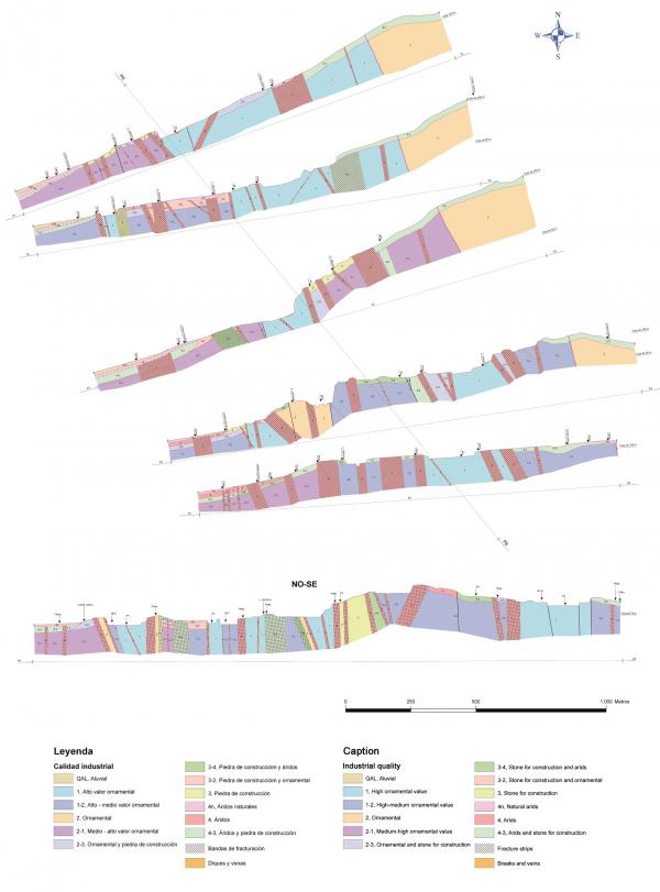
To know the vertical structure of the deposit in the visible part, the observations of the distinct sectors were integrated in observation stations (30 stations) in which the vertical variations and aspects of relative interest regarding fractures were synthesized, as well as the quality of the rock, with references to mineralogy, alterations, colour, size of grain, texture, structure, fissures, veins, enclaves, miarolitic cavities, flow structures, etc. taking into account its distribution and variations.
The vertical structures of the deposit was represented by means of geological cuts in which the different homogenous dominions and industrial qualities were marked out (figure nº 2).
- Mechanical surveys
The previous data on the vertical variation was complemented with the realization of 7 continuous surveys (304, 35 drills). Five of these surveys were done in exploitation depths of around 30 m so as to know the continuity of the deposit in depth. The other two surveys were done in the area next to change of fronts among granite Rosa Porriño and porphyric Rosa Porriño.
- Petrology
The petrological characteristics of the different granite fronts present, not only in the area of current exploitation but in the entire ambit of C. E. Benedicta, were studied in great detail in 38 stations of macroscopic observation, mainly in the exploitation area. Data was taken on the lithological nature of the rock and the state of alteration and fractures. Also microscopically studied, in light laminates, were 7 samples and the chemical analysis of 4 samples, the results of which, along with other existing data, permitted the petrological and geo-chemical characterisation in the main fronts present in the area of study, as well as obtain indications on the industrial quality of the rock. The result of this work is also integrated in the assignation of industrial quality in each homogenous dominion.
- Study of fractures
Given the characteristics of the fractures of the solid rock (concentration of the deformation in discrete, dense fractures that leave space with systematic fractures with very wide spaces), the study of blockmetry was not considered, which would be difficult to apply in big areas, nor was the realisation of the calculation of parameters for the estimation of the blocks size that can be extracted such as Jv, where, as a consequence of the wide spaces the cutting is done by diamond wire.
Analytic methods of fractures were applied to know the pattern of fractures at scale in the study area as well as its fit in the general structure of the area, which allows for knowing in depth the existing different fracture systems and their relations, emphasising the directions of the most persistent ones which have more affect on the exploitation of granite resources. With the aim of knowing better the disposition to "move forward", cutting measures with wire were made and its distribution in the extraction area analysed.
The results obtained: geological-mining maps of the concession (scale 1:10000) and the area of exploitation, implementation in a System of Geographic Information from where the different graphic exits have been generated. For digitalization, both geomedia and ArcGis formats were used.
Finally, with all the work done, the different existing granite fronts and their distribution were established, as also the fractures and the geometrical and cinematic characteristics as well as coincidence of the extension areas with the favourable areas for obtaining blocks, the distribution of stone in the exploitation area, the different existing industrial qualities, their characteristics and distribution in three dimensions.
Conclusion
The continuous and detailed cartography of industrial qualities, and the complementary data obtained have permitted obtaining good knowledge of the deposit Rosa Porriño and planning adequately making full use of this important resource for the next 30 years with guarantee of success. It is convenient to highlight that the detailed study of the rocks in the reserve area allows for reasonable extrapolation of the technological characteristics of granite, with the consequent saving and increase in the speed of studies.
Acknowledgements: To the company Pocasa-Porriñesa de Canteiras, S.A., in the person of José González Araújo, and to the project technical directors José Luis Delgado San Miguel and Manuel Ucha Calvo.