Pedro Oyhantçabal (a), Siegfried Siegismund (b), Karl-Jochen Stein (c), Jorge Spoturno (a)*
*(a) Depto. de Geología, Facultad de Ciencias Universidad de la República, Iguá 4225. (11400) Montevideo, Uruguay. E-mail: oyhantca@fcien.edu.uy - Tel: ++598 2 525 86 19. Fax: ++598 2 525 86 17
(b) Geoscience Centre of the University of Gottingen, University Göttingen, 37077 Göttingen, Goldschmidtstr. 3, Germany. E-mail: ssieges@gwdg.de - Tel: +49 +551 39-7929. Fax: +49 +551 39-9700
(c) Natursteininformationsbüro E-mail: Natursteinarchitektur@t-
Uruguay is a small country in South America (176215 km2) located between Brazil and Argentina and is part of the South American Platform. Its geology is quite diverse and consists of a Precambrian basement cropping out in the south (45%), and Paleozoic to Mesozoic sediments and basaltic flows that are part of the Paraná Basin in the north. This diverse geology offers an assorted variety of dimensional stones. Granites and marbles have a mining history of more than a century producing stones mainly for the regional market. An outstanding case is the black dolerite of Uruguay representing the most valuable black stone of the world with great demand in the international market and prices over 1000 US$/m3. The mentioned resources together with phyllites and some interesting potential dimensional stones like fuchsite bearing quartzites and conglomerates allow evaluating a promising future for the dimensional stone sector of Uruguay. Scarcity of evaluated reserves due to the lack of exploration and mining know-how is the main factor limiting the development of the production.
Introduction
With a population of 3 millions inhabitants, traditionally agriculture is the main economic activity. The country is highly dependant on the stability of the economy of the neighbouring countries. The regional recession of 1999 and 2002 affected seriously the economy but a gradual recovery is observed since 2003 and the GDP had increased at rates of ca. 6% during 2005 and 2006. Uruguay is a party state of the MERCOSUR agreement, a commercial union with Argentina, Brazil and Paraguay allowing free access to a market made up of 200 million inhabitants. The communications network of medium to high quality pavement is dense and the land has an electrification rate of ca. 95%, therefore opening of new mines should is not problematically.
The country does not have an important mining tradition; the mining sector represents less than 1% of the GDP but in spite of this small incidence, mining of raw materials for the growing metropolis of Buenos Aires during the 20th century represented a flourishing activity during several decades. Marbles, granites and slates were the main rock types mined as dimensional stones, but crushed rock and paving stones were also important products. The oscillations mentioned in the regional economy together with the lack of knowledge about the resources led to the decay of the sector and most of the quarries are currently closed.
Several reviews have considered the situation of the non metallic mineral resources of Uruguay (Bossi, 1978; Coronel, et al., 1987; Oyhantçabal et al., 2000), but published information about the dimensional stones of Uruguay is scarce (Medina, 1990; Bossi and Campal, 1991; Carmignani et al., 1998; Oyhantçabal et al. 2006). An updated revision of the situation and the potential of the dimensional stones sector of Uruguay is presented in this contribution.
Socio-economic importance of the dimensional stones in Uruguay
The mining activity of Uruguay is based on the exploitation of raw materials for the construction industry, dimensional stones, gold, agate, amethyst, and some industrial minerals like limestone clay for the cement and ceramics industries.
Mining production values ranges between 20 and 50 M dollars (21 M dollars for 2005) and account for around 0.2-0.5% of the GDP. Mining of gold is increasingly important representing in the 2005 ca. 20% of the sector. The sector employs around 2000 workers representing ca. 0.1% of the active population. Export amount average of around 5 Mio dollars per year signifies ca. 0.2% of the total exportations of the country. Gold, dimensional stones (granites), amethyst, agate and sand are the main export commodities. The impact in the production of dimensional stones of the regional crisis of 1999-2002 is evident as well as a gradual recovery since 2003. The significance of black dolerites in the total production of dimensional stones of Uruguay is also noticeable.
Legal framework
Mining activity is regulated by law number 15242 (Mining code of 1982) being the Dirección Nacional de Minería y Geología (DINAMIGE) the State agency responsible for the control of the mining activity. The State is the owner of all mineral resources and grants titles to carry out mining activities by private companies. Three different titles are considered in the code: the Prospecting License (up to 3 years), the Exploration License (up to 3 years) and the Concession to exploit (up to 45 years). An environmental authorisation is a pre-requisite before starting of the mining activities.
Overview of the geology of Uruguay
Uruguay is part of the South American Platform and its geology consists of a Precambrian basement cropping out in the south, and Palaeozoic to Mesozoic sediments and basaltic flows that are part of the Paraná Basin in the north (Fig. 1). Two Mesozoic rift basins related to the opening of the Atlantic Ocean are located in the south (Santa Lucía Basin) and east (Laguna Merín Basin).
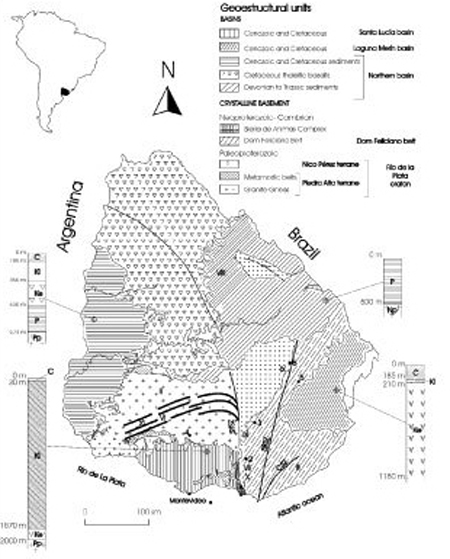
Main geological units of Uruguay (schema based on Preciozzi at al. 1985)
The Precambrian basement extends over nearly 45% of the country. A first division, proposed by Ferrando & Fernández (1971), differentiate Paleoproterozoic rocks in the south-west (Transamazonian Cycle: 2.2 - 1.8 Ga), and Neoproterozoic rocks in the east (Brasiliano Cycle: 900 - 550 Ma). Using a plate tectonic approach, Fragoso-Cesar (1980) defined the Río de La Plata Craton in the West (Paleoproterozoic) and the Dom Feliciano Mobile Belt in the East (Neoproterozoic). Recently a tectonostratigraphical terrane approach (Bossi et al. 1993; Basei et al. 2000) has been used to define different terranes in the pre-Brasilano Basement, the Paleoproterozoic Piedra Alta Terrane in the west, the Nico Pérez Terrane in the centre, and the Punta del Este Terrane in the east.
The Piedra Alta Terrane consists of two metamorphic belts: Arroyo Grande and Montevideo and a huge central granitic region with frequent gneiss and amphibolite xenoliths (Oyhantçabal et al. 2003). The oldest tectono-thermal event recorded in this terrane is Paleoproterozoic. The Nico Pérez Terrane is complex and build-up of different units: granulites of tonalitic to granitic composition; mafic and ultramafic rocks associated to metacherts; a platform succession comprising metaconglomerates, quartzites, and muscovite gneisses. Available data indicate Archean to Paleoproterozoic ages (Hartmann et al. 2001). In the easternmost part of the country the Punta del Este Terrane is indicative of a pre-Brasilano basement correlated to the African Namaqua Complex and was presumably formed at 1.0-0.9 Ga (Preciozzi et al., 1999, Basei et al. 2005).
The Neoproterozoic Dom Feliciano Belt (DFB) crops out in the eastern part of the country. From East to West it is composed of three main geotectonic units: a Granitic Belt, a Schist Belt and a Foreland Belt (Basei et al., 2000); a Neoproterozoic Schist Belt (Lavalleja Group) and an Ediacaran platform succession comprising sandstones, limestones, siltstones, and conglomerates (Arroyo del Soldado Group). Several continental-scale Neoproterozoic shear zones are characteristic of this belt (Sierra Ballena and Cordillera among others) and are associated with an important ductile and brittle overprinting of the country rocks. One of the outstanding examples is the Sierra Ballena Shear Zone, probably representing a Terrane boundary.

a).- Froche quarry of Moskart (Soca granite)
b).- Abandoned Endollar quarry of Moskart (Soca granite)
c).- Piedrahíta quarry of Pearl white marble (still stand)
d).- Pichinango quarry of black dolerite: blocks of Negro Absoluto and Oriental

e).- Piedrahíta quarry of Pearl white marble: stock of blocks and slabs
f).- Front of building covered with Tacuarembó sandstone
g).- Quarry of phyllite
h).- Handcrafted phyllite plates
Records of Ordovician to Silurian events have not been recognised yet and sedimentation related to the intracratonic Paraná Basin (Northern basin of Uruguay) began in the Devonian and continued during several marine to continental depositional cycles until the Late Cretaceous. The opening of the Atlantic Ocean in Late Jurassic to Early Cretaceous is recorded in the basaltic flows of the Paraná basin covering more than 106 km2 in Uruguay, southern Brazil, Argentina and Paraguay. Extension associated to this tectonic process also lead to the formation of rift-basins (Santa Lucía and Laguna Merín) filled with continental sediments and bimodal volcanism.
Cenozoic is characterised by continental deposits restricted to small basins and thin loess cover of some crystalline areas. A stable craton is the Cenozoic scenario and sedimentation was controlled by neotectonics and eustatic variations of the sea level.
Dimensional Stones from Uruguay
Granites and related igneous dimensional stones
Different types of igneous rocks are mined in Uruguay for dimensional stones. Main types are alkaline granites, granodiorites and dolerites. Most of the production is exported as raw blocks but two sawmills with modern equipment also produce polished slabs and floor tiles.
Gray granites
Paleo as well as Neoproterozoic plutons located in different areas of the basement have provided grey granites: Soca, Chamangá, Cerro Aspero and Cufré among others (see locations in Fig. 1). Information about the more important districts (Chamangá and Soca) is expanded below.
Soca granite
The Paleoproterozoic Soca pluton (see location in Fig. 1) is a dark coloured coarse-grained leucocratic granite. It is composed mainly of quartz, alkali-feldspar, plagioclase and iron-rich biotite and amphibole. The texture is porphyritic with euhedral megacrysts of microcline up to 7 cm long in a coarse-grained matrix. Petrographic features, mineral chemistry and geochemistry indicate that it is an alkaline granite with features typical of A-type Proterozoic Rapakiwi granites. The granite is overprinted by latter tectono-thermal events probably associated with the activity of Sarandí del Yi Shear Zone, that are responsible for brittle deformation observed especially in the south-east and the development of a secondary paragenesis of stilpnomelane, chlorite and bluish-green amphibole. This paragenesis could be related with the origin of the dark greenish grey colour of this leucocratic granite (Oyhantçabal et al., 1998).
Two commercial varieties are mined in the surroundings of Soca town: Moskart and Labradorita oriental. The available geotechnical parameters are presented in Table 2. The mentioned brittle overprinting determines some problems in the polished surface that can be overcome with resin treatment. The production in the period 1997 – 2005 shows strong oscillations and range between 0 (2002) and 798 (1998) Tons/year. A historical maximum of 3476 Tons/year was obtained in 1991.
Chamangá granite
This Paleoproterozoic intrusion (see location in Fig. 1) is a light grey coloured medium -grained granodiorite. It is composed mainly of subhedral plagioclase, quartz, alkali-feldspar and biotite. Main accessories are epidote, sphene, garnet and opaque minerals. The texture is very homogeneous, equigranular, sometimes porphyritic with rare alkali-feldspar megacrysts up to 2.5 cm. Mafic enclaves and pegmatitic dikes occur only occasionally. Brittle tectonic overprinting is slight and joints are spaced normally several meters according to an orthogonal pattern making possible the exploit of blocks of commercial dimensions with good yield. Available geotechnical parameters are shown in Table 2.
Two commercial varieties are mined in the surroundings of Chamangá River: Grey Chamangá and Loyner grey. The average production for the period 1997 – 2005 was 2166 Ton with an exceptional maximum in 1993 of 20909 Ton. The main market for this grey granite is Japan. Considering the properties and homogeneity of this stone and the minor influence of joints it is considered that it has a good potential provided that satisfactory cost/price ratios are accomplished with adequate mining techniques and marketing strategy.
Coloured granites (pink and red)
Pan de Azúcar pluton and associated syenite deposits:
The Pan de Azúcar Pluton, associated with the Sierra de las Animas Complex, is a circular intrusion with a diameter of approximately 5 km including syenites, quartz syenites, and granites. The shape of the intrusion and the association with volcanics of similar age suggest a ring-complex structure for both the pluton and the nearby intrusions. A recent Ar/Ar amphibole age indicates late Neoproterozoic age for this magmatism (Oyhantçabal et al. 2006).
The lithologies used as dimensional stones are syenites and granites. Syenites are present in the marginal zone of the Pan de Azúcar intrusion. They are grey to pink coloured and very coarse-grained. Perthitic orthoclase up to 4 cm and interstitial amphibole, pyroxene and biotite are the main minerals. Accessory minerals include apatite and zircon. Quartz syenites crop out in the central part of the pluton. They are medium-grained, colours ranging from grey to brownish-pink to red. The mineral composition is similar to that of the syenites, but a small amount of interstitial quartz is present.
As is typical for alkaline granitoids, the postorogenic setting is connected with fewer tectonic overprint and alkali feldspar exhibits a wide palette of colours in the different intrusions (grey, deep red, brownish red, etc). These facts together with the accessibility of the area determines that since the beginning of the 20th century this district constituted the main area of Uruguay producing a variety of colours and designs of dimensional stones. The most important commercial varieties are: Guazubirá (medium-grained and reddish pink), Artigas (coarse-grained and mixed grey and pink colour), Bodega (Medium grained and deep red), Sara Pink (fine grained and pink), etc. The average production for the period 1997 – 2005 was 1502 Ton with an exceptional maximum in 2000 of 3800 Ton (these data include the production of some small quarries of coloured granites from other parts of the country). The major market for these granitoids is regional (cities of Buenos Aires and Montevideo) and in the last decades also Japan. The heterogeneity of colour and inadequate market strategies were the main problems that led to the closure of most of the quarries. In spite of the present situation it is considered that the potential is good, being a prerequisite the evaluation of resources, cost/price ratios and market possibilities.
Black dolerite
A significant black stone producing province is associated with a Paleoproterozoic dolerite dyke swarm intruded in the Piedra Alta Terrane of the Río de la Plata Craton (Fig. 1). The swarm extends for near 160 km trending ca. 060º, the length of the individual dykes reaches some kilometres and the width ranges between 10 and 50 m. The composition is tholeitic and two subprovinces with high and low Ti respectively have been recognised (Bossi & Campal, 1991; Bossi et al. 1993). The dolerites are composed of plagioclase, clinopyroxene an opaque minerals and the texture is subophitic. Biotite, apatite and interstitial intergrowths of quartz and alkali feldspar (micropegmatite) are the main accessory phases. Rims of uralitic amphibole and chlorite are scarce.
Two main varieties of dolerite are mined: one is deep black and fine grained (Negro absoluto) while the other is dark grey-black and medium grained (Negro oriental). The first is more appreciated in the market but blocks of commercial dimensions are not common. Colour inhomogeneities are seldom observed and are associated to pockets of white coloured quartz –alkali feldspar intergrowths. The main problem for the production of commercial blocks is the abundance of joints that determines low extraction yields (<10%). The production shows strong oscillations and ranges between 919 and 3797 Tons/year for the period 1997-2005.
This black stone has a great demand in the international market with prices over 1000 US$/m3. Good quality and the world demand for deep black stones creates a high potential for these rocks although research is needed for unsolved problems in exploration and mining.

a).- Moskart grey granite (Soca granite)
b).- Artigas syenite (Pan de Azúcar pluton)
c).- Guazubira syenite (Pan de Azúcar province)
d).- Negro Absoluto black dolerite (Florida dolerite swarm)
Marble
Marble occurrences in Uruguay are related with the Neoproterozoic low- to medium- grade metamorphic supracrustal successions of the Dom Feliciano Belt. In some cases the deposits are related with aureoles of contact metamorphism around granitic intrusions.
The main production provinces are:
The Polanco area: white and coarse-grained marbles related to the metamorphic aureole of the Polanco Granite. Aggregates of radial tremolite are common as contact metamorphism minerals in these marbles. Reserves are small because most of the deposits correspond to roof-pendants in the intrusion. Jointing is additionally important and therefore the blocks are small-sized. Coarse-grain, small size of the blocks and small volume of reserves make these marbles interesting only for internal markets. Most of the quarries are at the moment closed.
The Minas - Pan de Azúcar area: varicoloured marbles (white, grey, red, green and black) were exploited in small quarries using inadequate technologies and excess of explosives. Most of the quarries are presently closed. This province has a potential for exploration of valuable marble varieties due to the interesting palette of colours and designs.
Mining of marbles began in Uruguay in the first decades of the 20th century. The market was internal and regionally the expanding city of Buenos Aires (Argentina). The variability of colours together with the jointing associated to tectonics and to erroneous extraction techniques besides unfavourable cost/price ratios and poor marketing strategies led to a continuous decay in the production since 1990 (2900 Ton) and ruined most of the quarries (39 Ton in 2005). For the internal market the production must also compete with imported marbles from Argentina, Brazil and even Spain. Available Geotechnical parameters are presented in Table 2.
Phyllites
These building stones are associated with the Neoproterozoic thrust and fold Schist Belt of the Dom Feliciano Belt. The mining province is located between the localities of Pan de Azúcar and Minas (Fig. 1). The quarries are located in the limbs of a folded calcsilicate sequence, where bedding and foliations are parallel.
The main lithotype is a fine banded calcareous phyllite. The mineralogy is sericite, chlorite, calcite and quartz and the texture is lepidoblastic to grano– lepidoblastic. The palette of colours is quite varied: light green, grey, dark grey, reddish and black. The mined stone is splitted in slabs 0.5-2 cm thick and manufactured in two ways: irregular slabs and dimensional floor tiles. Geotechnical parameters are presented in Table 2. The average production the period 1997-2005 is around 3991 Ton. A historical maximum of 13000 Ton is observed in 1993.
Potential resources are high being the variations in demand of the regional market the main limitation and the cause of several flourishing and decays cycles in the activity. Exploration for colours and qualities is a prerequisite for the development of the sector.
Sandstones
Mildly lithified sandstones of the Tacuarembó formation (Triassic, Northern Basin, see location in Fig. 1) have been mined discontinuously. These quartzose medium-grained sandstones are light reddish to grey coloured and have parallel bedding. The sandstones were mined during the first decades of the 20th century only for the internal market. After several decades of inactivity a small production started a few years ago (774 Ton in 2004 and 1014 Ton in 2005). Geotechnical parameters are not available.

e).- Artigas marble (Minas – Pan de Azúcar area)
f).- Maroco marble (Minas – Pan de Azúcar area)
g).- Collection of palette of Phyllites
h).- Sandstones (Tacuarembó formation)
Potential for other Dimensional Stones
Fuchsite bearing quarzites
The eastern margin of the Nico Perez Terrane is characterized by a lithological association of quarzites and ultramafic metamorphic rocks cropping out for around 200 km (Spoturno et al. 1986; Oyhantçabal & Vaz, 1990). The ultramafic rocks of this association are actinolitites and tremolitites with high Cr and Ni contents (~2000 ppm) suggesting the protoliths are pyroxenites and or peridotites. The accessory minerals of the associated quartzites are muscovite, sillimanite and fuchsite. When the latter is abundant the quartzites have light emerald green colour and may represent an interesting valuable stone.
Conglomerates
Strongly lithified paraconglomerates (Las Ventanas formation, Ediacaran, see location in Fig. 1) are associated with the molasses of the Dom Feliciano belt. The consolidation of these conglomerates is so strong that they usually crop out as rounded boulders similar to granitic rocks and could be apt for saw processing and manufacturing of floor tiles. The variability in colours (grey, reddish, green, etc.) of the rounded pebbles composed of granite, marble, phyllite, rhyolite, etc, makes these conglomerates represent an interesting potential dimensional stone.
Anorthosites
Several mafic intrusions have been identified in the Paleoproterozoic Piedra Alta Terrane. Besides the interest for black stones, some of these plutons contain anorthosite levels that could represent prospects for light coloured (near white) dimensional stones.
Conclusions
Although small and without long tradition in mining, Uruguay has a complex geology including Archean to Neoproterozoic crystalline rocks belonging to different terranes. This diverse geology offers an assorted variety of dimensional stones. In some cases (granites and marbles) mining has a history of more than a century of supplying natural stones for the metropolis of Buenos Aires and in smaller amounts to Montevideo. The country has also delivered dimensional stones to Europe and Japan during the last decades. An extraordinary case is the black dolerite of Uruguay representing the most valuable black stone of the world. The demand for these dolerites exceeds the supply possibilities, the scarcity of evaluated reserves due to the lack of exploration and mining know-how is the limiting factor for an adequate production. Phyllites and some potential dimensional stones like fuchsite bearing quartzites and conglomerates allow evaluating a promising future for the dimensional stones of Uruguay.